
Lakeland flood insurance has become a growing concern for homeowners throughout Central Florida, especially after recent inland storm events showed how quickly heavy rainfall can overwhelm streets, lakes, and drainage systems across Polk County. While many Florida residents associate flood damage with coastal storm surge, Lakeland’s geography creates a very different type of inland flood exposure tied to intense rainfall, overflowing retention systems, and low-lying areas surrounding the city’s 38 named lakes.
- Local Reality: Lakeland’s 38 named lakes, former sinkhole depressions, and intense summer rainfall create flood exposure well beyond traditional coastal concerns.
- The Coverage Gap: Standard homeowners insurance does not cover rising water entering your home from outside ground level.
- Coverage Options: Both NFIP and private flood insurance options are available, with private policies often offering higher limits and broader protection.
- The Independent Advantage: Think Safe Insurance compares multiple flood insurance options to help Lakeland homeowners evaluate pricing, coverage, and local flood exposure side-by-side.
From historic neighborhoods like Dixieland and South Lake Morton to growing areas around Lakeland Highlands, water behavior can vary dramatically depending on elevation, drainage design, nearby lakes, and how quickly runoff moves during major storms. Because protecting your home matters, understanding Lakeland’s unique inland flood patterns is critical when evaluating your insurance options.
Does Lakeland Really Have a Flood Risk?
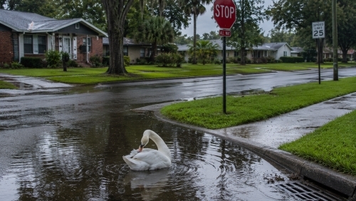
Yes. One of the biggest misconceptions in Polk County is the belief that inland cities like Lakeland face minimal flood exposure compared to coastal Florida. In reality, heavy rainfall events regularly create flooding problems throughout the Lakeland area, especially near older drainage systems, low-lying roads, and lake-adjacent neighborhoods.
Hurricane Ian in 2022 reinforced this reality across Central Florida. Lakeland experienced wind gusts reaching 78 mph, and approximately 63,500 Lakeland Electric customers lost power during the storm. At the same time, the Peace River crested at 10.8 feet — extremely close to its record level of 11.1 feet.
Many homeowners throughout areas near Lake Hollingsworth, Beacon Hill, and portions of Cleveland Heights discovered that inland flooding often develops from overwhelmed drainage systems and rapid freshwater accumulation rather than coastal surge. Roads surrounding Memorial Boulevard, U.S. 98, and portions of Lakeland Highlands Road can experience severe standing water after prolonged tropical rainfall.
Flood risk also varies dramatically from one street to the next. A property sitting slightly lower near a drainage swale or retention pond may face a completely different exposure profile than another home only a few blocks away.
Lakeland’s 38 Lakes and What They Mean for Flood Exposure
Unlike Winter Haven’s connected chain-of-lakes system, Lakeland contains 38 individually named lakes spread throughout the city. These lakes are one of the defining characteristics of Lakeland’s geography and directly influence how water drains during severe rainfall events.
Many Lakeland-area lakes formed through ancient sinkhole activity tied to Central Florida’s karst geology. That matters because sinkhole-adjacent terrain can create unusual drainage behavior where water collects rapidly in certain depressions while nearby streets remain relatively dry.
Homes near Lake Morton, Lake Mirror, and the Lake Hollingsworth area often sit within older portions of the city where road elevations, storm drains, and lot grading were developed decades ago. Meanwhile, growing suburban areas in Lakeland Highlands frequently rely on modern retention systems that can still become stressed during consecutive days of tropical rain.
Properties near landmarks like Lakeland Regional Health, Florida Southern College, and the Publix Super Markets headquarters may appear elevated during normal weather, but rapid rainfall accumulation can still overwhelm nearby drainage corridors and create street flooding.
Because many Lakeland lakes sit in former sinkhole depressions, water movement during storms is often less predictable than homeowners expect. Many residents underestimate how much localized elevation changes influence flood behavior across Polk County.
FEMA Flood Zones in Lakeland — What Zone X Actually Means
Flood zones help estimate long-term flood probability, but they do not guarantee where water will or will not go during an extreme storm.
Many Lakeland homeowners are surprised to learn that approximately 25% of flood claims nationally occur in moderate- or low-risk flood zones. That includes many properties labeled as Zone X.
Zone X generally means a property sits outside the official 100-year floodplain. Flood insurance is usually not required by lenders in these areas, but flood exposure still exists — especially near lakes, retention systems, or older drainage infrastructure.
Meanwhile, homes in Zone AE or Zone A fall within Special Flood Hazard Areas (SFHA). If these properties carry federally backed mortgages, flood insurance is typically required.
Some homes in Dixieland, South Lake Morton, and portions of Beacon Hill may sit outside mandatory flood zones while still facing meaningful freshwater flood exposure during severe rainfall events. Flood maps primarily analyze historical probability models and do not always capture modern drainage stress caused by new development, roadway expansion, or increasingly intense rainfall patterns.
The City of Lakeland launched a Flood Risk Portal in January 2025 that allows residents to research local flood information and property-specific concerns at lakelandfl.withforerunner.com/properties.
The Peace River, Heavy Rainfall, and Flash Flooding
The Peace River basin plays a major role in regional flood behavior throughout Polk County. During tropical systems and prolonged summer rain events, water levels throughout the basin can rise quickly and impact surrounding drainage networks.
Flash flooding across Lakeland often develops from several combined factors:
- High rainfall intensity over short periods
- Saturated soil from prior storms
- Runoff flowing from elevated roads and commercial development
- Drainage systems struggling to keep up with storm volume
- Retention ponds reaching overflow capacity
Busy corridors around I-4, U.S. 98, and Memorial Boulevard generate enormous runoff during severe storms because large paved surfaces prevent water absorption. Water then moves into nearby residential streets, swales, lakes, and retention systems.
This inland freshwater flooding behaves very differently than coastal surge, which is why many homeowners moving from Brandon, Plant City, Haines City, Auburndale, Bartow, Winter Haven, or Polk City are surprised by how quickly water accumulation can occur around Lakeland’s lake systems.
NFIP vs. Private Flood Insurance for Lakeland Homeowners
Flood insurance generally falls into two major categories: NFIP coverage and private flood insurance.
The National Flood Insurance Program (NFIP) is federally backed and provides standardized flood coverage. Current NFIP coverage limits include:
- $250,000 maximum building coverage
- $100,000 maximum contents coverage
NFIP policies also carry a standard 30-day waiting period before coverage begins unless a specific loan-closing exception applies.
Private flood insurance has expanded significantly across Florida and may offer:
- Higher building and contents limits
- Replacement cost coverage for belongings
- Shorter waiting periods
- Additional living expense coverage
- Broader underwriting flexibility
Some newer homes in Lakeland Highlands or modern developments near south Lakeland may qualify for competitive private flood pricing, while older homes near Lake Morton or Dixieland sometimes fit better within NFIP structures depending on elevation and prior claims history. Comparing both options side-by-side is often the smartest approach.
How Polk County’s CRS Rating Affects Your Flood Premium
Flood insurance pricing in Lakeland can be influenced by Community Rating System (CRS) participation. The City of Lakeland currently holds a FEMA CRS Class 7 rating, which provides eligible NFIP policyholders in high-risk flood zones with approximately a 15% discount on premiums.
Separately, Polk County maintains a FEMA CRS Class 6 rating in certain unincorporated county jurisdictions, which can provide up to a 20% reduction for qualifying NFIP properties in those specific areas.
These are two separate ratings that apply differently depending on whether the property falls within Lakeland city limits or qualifying unincorporated Polk County areas. Because flood rating structures can become complex, working with a licensed flood insurance agent helps ensure discounts are applied correctly.
Step-by-Step: How to Review Flood Insurance in Lakeland
- Confirm your current homeowners policy — verify whether you have any flood insurance protection at all. Most homeowners policies exclude flood damage completely.
- Check your flood zone using FEMA flood maps and Lakeland’s Flood Risk Portal at lakelandfl.withforerunner.com/properties.
- Evaluate nearby lakes and retention systems — homes near Lake Hollingsworth, Lake Morton, or low-lying drainage corridors may face additional exposure even outside mandatory flood zones.
- Compare NFIP and private flood options — coverage limits, waiting periods, deductibles, and pricing can vary significantly.
- Review contents coverage carefully — replacing flooring, furniture, electronics, and appliances after water damage is more expensive than most homeowners expect.
- Work with an independent insurance agency to compare multiple options and identify the strongest long-term protection for your specific property.
Frequently Asked Questions
Do homes in Zone X really need flood insurance in Lakeland?
In many cases, yes. Zone X properties are outside the official 100-year floodplain, but flooding still occurs regularly in moderate- and low-risk zones throughout Central Florida. Heavy rainfall, lake overflow, and drainage backups can still create major losses.
Does homeowners insurance cover flooding from Lakeland storms?
No. Standard homeowners insurance does not cover rising water entering from outside the structure. Flood damage requires a separate flood insurance policy.
What is the difference between NFIP and private flood insurance?
NFIP policies use standardized federal coverage structures and limits, while private flood insurance can offer higher limits, broader coverage, and shorter waiting periods depending on the property.
Can inland areas around Lakeland still flood during hurricanes?
Yes. Inland flooding from prolonged rainfall is one of the biggest flood risks throughout Polk County. Slow-moving tropical systems often create severe freshwater flooding well away from the coast.
Get a Lakeland Flood Insurance Quote

Protecting your home in Lakeland means understanding how inland flooding, lake geography, rainfall intensity, and drainage infrastructure all interact across Central Florida. Think Safe Insurance helps Lakeland homeowners compare both NFIP and private flood insurance options based on the specific characteristics of their property, location, and risk profile.
Call 863-356-4600 today or request your quote online to review your Lakeland flood insurance options.
Also serving Lakeland residents: Lakeland Homeowners Insurance | Lakeland Auto Insurance
When you think insurance… Think Safe.
Last Reviewed: June 2026